
Tuesday is expected to be the UK’s hottest day of the year as a heatwave affects large parts of the UK.
Parts of south-east England are forecast to reach temperatures of 32C (90F).
The Met Office said some places in England and Wales are very likely to meet heatwave criteria later.
But it might be short-lived – with a yellow alert for thunderstorms issued by the Met Office across large parts of both nations later in the week.
A Yellow Heat Health Alert has been issued for all areas of England – except for the North East and North West – by the UK Health Security Agency (UKHSA).
This is the second of four tiers of alerts – below amber and red – and means the heat is “unlikely to impact most people” but could affect the elderly and vulnerable.
The UKHSA has warned the hot spell may make an “observed increase in mortality across the population likely, particularly in the 65-plus age group or those with health conditions, but impacts may also be seen in younger age groups”.
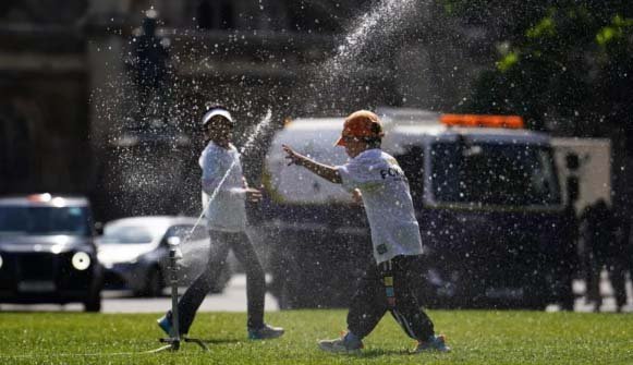
Children keep cool by running through a sprinkler on Parliament Square in London
It also warns that there will likely be an increase in the demand for remote health care services, and that internal temperatures in hospitals and care homes may become too hot for clinical risk assessments to take place.
Many parts of the country will experience temperatures four-to-five degrees warmer than average for this time in July, BBC Weather said.
In a post on X, the Met Office showed the differences in the weather between some parts of the UK on Monday, with Charlwood in Surrey basking in 29.6C heat while Sennybridge in Wales shivered in just 4.9C.
The hottest day of the year so far came on 19 July when a temperature of 31.9C was recorded at St James’s Park in central London.
Is this a heatwave?
The Met Office defines a heatwave in the UK as “when a location records a period of at least three consecutive days with daily maximum temperatures meeting or exceeding the heatwave temperature threshold.”
It is likely that criteria will be met in a few places on Tuesday.
In the London area that threshold is 28C. For Scotland, Northern Ireland, Wales and most of northern and western England it is 25C.
If nowhere in Scotland reaches 25C on Tuesday, it will be the first July since 2010 that temperatures there have not reached this level.
BBC Weather lead forecaster Chris Fawkes said: “After such a hot day the heat will be very slow to fall away, giving an uncomfortable night for sleeping with temperatures still above the 20C mark in many towns and cities.”
He added that Wednesday would be another hot day: “It could turn out to be a hotter day in parts of central southern England and parts of the Midlands with temperatures peaking around 31C to 32C.
“In the south-east of England temperatures are more likely to be a few degrees lower, but still reaching about 29C.”
The drier weather for much of the country is expected to break on Thursday, which is when the yellow warning for heavy rain and thunderstorms issued by the Met Office comes into force.
The thunderstorm warning starts at 12:00 BST on Thursday and ends at 23:59.
Most of southern England, the Midlands, parts of Wales and much of northern England are covered by the alert, which warns of “lightning, hail and gusty winds” that could lead to some disruption.
Warm weather is due to return by Friday – below heatwave criteria but still about 20C in many areas – with some rain showers.
The rest of the month is expected to bring breezy conditions to the north west, and drier and brighter weather to the south east.
A more widely settled period is expected towards the middle of August.